| Home : About Us : Contact Us : Query : Sitemap | Language Options : |
 |
 |
| The Himalayas are not merely a geographical feature, a range of mountains. they epitomise people's civilisational identity that goes back to the dawn of history. If these majestic mountains were not there, the rain clouds sweeping up from the Indian Ocean. |
| India Tours | India Adventure Tours | Nepal Adventure Tours | Bhutan Tours | Tibet Tours | Himalayan Adventure Tours |
|
Uttarakhand Tours 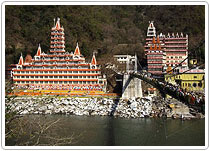 Uttarakhand became 27th state of India on November 09, 2000 formed from the hill districts of Uttar Pradesh after mass agitations. At the time of formation state was named Uttaranchal but in January 2007 according to the wishes of the peoples of the state government changed the name to Uttarakhand. Dehradun, the largest city of the state became provisional capital and high court of the state is in Nainital. Garhwal & Kumaon are 2 regions with total 13 districts, seven in Garhwal & six in Kumaon region. Northern part of the state is covered with Great Himalayan Peaks and Glaciers and the source of many rivers including the national river of India-Ganga. Uttarakhand became 27th state of India on November 09, 2000 formed from the hill districts of Uttar Pradesh after mass agitations. At the time of formation state was named Uttaranchal but in January 2007 according to the wishes of the peoples of the state government changed the name to Uttarakhand. Dehradun, the largest city of the state became provisional capital and high court of the state is in Nainital. Garhwal & Kumaon are 2 regions with total 13 districts, seven in Garhwal & six in Kumaon region. Northern part of the state is covered with Great Himalayan Peaks and Glaciers and the source of many rivers including the national river of India-Ganga.Uttarakhand is also called Dev Bhoomi or the "Land of the Gods" because of the presence of many important Hindu Religious places and in ancient Hindu scriptures the combined regions of Kedarkhand & Manaskhand know as Uttarakhand. GARHWAL DIVISION Western parts of the state know as Garhwal have 07 districts and people of this part generally called Garhwali. Districts in Garhwal Division of Uttarakhand : 1. Dehradun 2. Uttarkashi 3. Tehri Garhwal 4. Pauri Garhwal 5. Haridwar 6. Chamoli 7. Rudraprayag Famous tourist places in Garhwal, Uttarakhand Mussoorie, Dhanolti, Chakrata, Chamba, Narendra Nagar, Shivpuri, Khirsu, Auli, New Tehri & Pauri. Religious Places in Garhwal, Uttarakhand Many religious places including the Char dham the 04 most sacred shrines of Yamunotri, Gangotri, Kedarnath & Badrinath are in this part of the Himalayas. Sacred city of Haridwar - the gateway of the gods and the starting point of chardham yatra tour also host Kumbh mela once in twelve years. Rishikesh is also called Yoga capital of the World and visited by many Indian and foreign tourist for Yoga and meditation. Other places of Religious importance are Panch Badri and Panch Kedar visited by many Hindus from around the world. Trekking routes in Garhwal, Uttarakhand Garhwal region is a paradise for Adventure tour lovers and many adventure tour options are available including – Many famous Trekking routes in the lower and higher Himalayan region few are Har – Ki-Doon trek, Dodi Tal trek, Nandanvan, Tapovan, Kuari Pass trek, Bedni Bugyal Trek, Sunderdunga Valley Trek, Nanda Devi Sanctuary Trek, Khatling Glacier Trek, Panwali Kantha Trek, Kedal Tal Trek, Ruinsara Lake Trek, Kedar Kantha Trek, Valley of Flowers Trek, Hemkund trek, Nagtiba trek and many more options for Adventure lovers. Skiing in world famous slopes of Auli or in Dayara Bugyal & Mundali White water river rafting in Ganga, Tons, Yamuna, Alaknanda or Kali Hot Air Ballooning, Camping, water sports in Asan Barrage, snow camping, rock climbing or mountain climbing in one of the many famous Himalayan peaks of Garhwal. For every Adventure traveller many options are available in this part of Himalaya. KUMAON DIVISION Eastern part of the state know as Kumaon have 06 districts and people of this part generally called Kumaoni. Districts in Kumaon Division of Uttarakhand : 1. Almora 2. Nainital 3. Udam Singh Nagar 4. Bageshwar 5. Pithoragarh 6. Champawat Famous tourist places in Kumaon, Uttarakhand Nainital, Ranikhet, Almora, Kausani, Binsar, Chaukori, Mukteshwar, Bhimtal, Munsyari & Sitlakhet. Trekking routes in Kumaon, Uttarakhand Milan Glacier, Ralam Glacier, Adi Kailash, Khalia Top, Kafni Glacier, Pindari Glacier, Sunderdunga Valley trekking and many more options for adventure traveller. Garhwal Garhwal is smack in the middle of the Himalayas, with Himachal Pradesh in the West and North-West; Tibet in the North; the plains of Western Uttar Pradesh in the South and Kumaon in the East. History of Garhwal The history of Garhwal is older than that of the Ramayan and Maha- bharata. It is a land of popular myths, like that of Lord Shiva appearing as Kirat, of Urvashi, Shakuntala and the Kauravas and Pandavas. Worship of Lord Shiva is pre-dominant in this region. Historically, it has been described in the ancient text of Kedarkhand to extend from Gangadwar (modern day Hardwar) in the South to the high mountains in the North, and from the Tamsa (Tons) river in the in the West to Buddhachal (probably the Nanda Devi group of peaks between Garhwal and Kumaon) in the East. Today it is an administrative division of the raising state of Uttaranchal, comprising the districts of Chamoli, Dehradun, Pauri, Tehri and Uttarkashi. Places of interest in Garhwal Char Dham 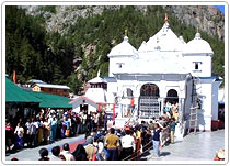 With the majestic and mystifying Himalayas as the backdrop, the four most holy pilgrimages of India never cease to amaze travelers and visitors. Char Dham, or the four pilgrimage centers, comprising of Badrinath, Kedarnath, Gangotri and Yamunotri are frequented by the religious minded as well as those intrigued by the remnants of bygone years. With the majestic and mystifying Himalayas as the backdrop, the four most holy pilgrimages of India never cease to amaze travelers and visitors. Char Dham, or the four pilgrimage centers, comprising of Badrinath, Kedarnath, Gangotri and Yamunotri are frequented by the religious minded as well as those intrigued by the remnants of bygone years. Dehradun Surrounded by lush green forests and hills, Dehradun has always been a favourite with the tourists. Dehradun, the district headquarter is located at an altitude of 2,200 feet above sea level in the picturesque Doon valley. It is endowed with a pleasant, moderate climate & is well connected with other important places. Mussoorie Mussoorie or the "Queen of Hills", as it is Popularly known is located in the Garhwal hills. Due to its immense natural beauty, Mussoorie is known as the queen of hill stations. In 1820 Captain Young from the British army was influenced by the beauty of this place and made this place his residence. This marked the foundation of a hill station called Mussoorie. The name, Mussoorie, is derived from plants of 'Mussoorie' which were found in abundance here. After its discovery, this hill station gradually developed as a center of education, business, tourism and beauty. Kumaon Kumaon, like neighboring Garhwal, lies right on the main axis of the Great Himalaya range. From the eastern ramparts of Nanda Devi, 25,645 feet, on through Nanda Kot and the Panchchuli group, both twenty two thousanders, finally meeting up with the Nepalese Api group along the gorge of the Mahakali, the Great Himalaya rises in a gentle sweep from the plains of Uttar Pradesh. Kumaon is a land of fairs and festivals, legends and mythology snow capped mountains and glaciers, valleys and glades, verdant forests and alpine meadows, lakes and gushing streams, birds and animals, butterflies and flowers, all combine to make a sum of delight unsurpassed elsewhere. A peep into the history of Kumaon The people of Kumaon are said to have been the original inhabitants of the Kols (also related to the Mund, ethnic group). One of their groups migrated to Kumaon after they had been defeated by the Dravidians. The Shilpkars of Kumaon are said to be the descendants of the Kols. The Kirats are believed to have been the ancestors of the tribes which are today known as Shaukas, Banrajis. Tharus and Boksas. While the Shaukas were active from the Tarai region to Tibet, the Tharus and Boksas confined themselves to the Tarai, and the Banrajis had always lived in 'splendid' isolation. Later on, the Khasas came from West Asia and settled down in many parts of Himalaya. A major portion of the population of Kumaon is said to have descended from the Khasas. Places of Interest in Kumaon Nainital 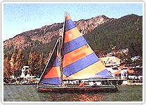 Naini, a word that almost brings the cool air with it is a secret hide out of the tourists each year. Situated at an altitude of 1,938mtrs, this dreamland town with its beauteous splendor is one of the most popular tourist resorts of the country. The nucleus of Naini Tal's exquisite beauty is her lake which is a haven for water sports like Yachting, Kayaking, Canoeing and Boating. Naini, a word that almost brings the cool air with it is a secret hide out of the tourists each year. Situated at an altitude of 1,938mtrs, this dreamland town with its beauteous splendor is one of the most popular tourist resorts of the country. The nucleus of Naini Tal's exquisite beauty is her lake which is a haven for water sports like Yachting, Kayaking, Canoeing and Boating. Almora Perched on a hillock at an elevation of 1,646m, Almora appears like a large horse shoe, Sitoli forming the front arm and the bazaar the other. In the 16th century, the capital of the Chand rulers was shifted from Champawat to Almora. It is the district head quarter and the Vivekanand Hill Agricultural Laboratory, as well as the defence agricultural research laboratory are housed there. Pithoragarh Pithoragarh (1,645m) is strategically important. On the north it is bound by Tibet and on the east by Nepal. Located in the midst of the extensive Sor valley, Pithoragarh is serenely beautiful. The famous international pilgrimage of Kailash Mansarovar passes through this region. The famous Adi Kailash as well so the glaciers, Milan, Ralam and Namik are located in this district. Pithoragarh is famous for its leather, woollen, wooden and cane goods.
|
||||||||||||||||
|
Cricket has been an organized adult game since the seventeenth century when it first took the fancy of English gentlemen lying low in their country estates at the time of the Civil War.
|
Camping is the best way of enjoying the wonders of nature given to Himachal and sharing the warmth of its people. You can carry your own gear along or opt for any one of the several camps that are pitched in various parts of the State.
|
||
This Site is Designed, Developed and Promoted by Unimans Creation & |
